 A Completion
Report for
A Completion
Report forRound Island Lighthouse Breakwater
A Completion
Report for
Mississippi Gulf Fishing Banks, Inc.
Performed by PRIMOFISH.COM on December 20, 1997
 Introduction
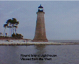
The Round Island Lighthouse was built 3 miles south of Pascagoula, Mississippi in 1833. One of the oldest structures of its type on the Gulf Coast, the 44 foot tall abandoned lighthouse has always had a problem with vandalism, but now erosion threatens to undermine the tower. In 1985 the City of Pascagoula assumed ownership of the lighthouse and pursued efforts to preserve this historic landmark. In 1987, 38 volunteer sailors from the USS Wisconsin stacked 23 tons of cement bags and 14 tons of sand around the lighthouse, but by 1989 this had all washed away. In 1990, an area 500 feet by 30 feet west of the lighthouse was dredged six feet below mean tide and the dirt was placed around the lighthouse and stabilized with 500 pounds of limestone rip rap which was covered with vegetation. However, the lighthouse continues to be threatened by erosion. In January of 1997, Lighthouse Digest placed the lighthouse on it's Doomsday List.
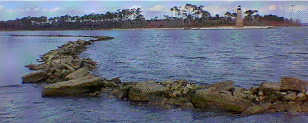
The latest effort is to build a breakwater of concrete rubble seaward of the lighthouse and later backfill 31 Acres with 355,000 cubic yards of sand. Mississippi Gulf Fishing Banks, Inc. (MGFB) is a non-profit organization experienced in building fishing reefs using concrete rubble. MGFB agreed to construct the initial portion of the breakwater during the Summer of 1997 utilizing Tidelands Funds and it's contractors, Borries Construction and King Marine Services. MGFB contracts King Marine on an annual basis to provide a spotter boat and supervise all of it's reef construction efforts throughout the year. Borries provided the Tug/Barge and loading/unloading of the concrete rubble for this project.
The purpose of this report is to show the end results of the construction efforts for use by the Engineer in determining whether or not the finished breakwater meets with his intentions and if further measures are needed to make the breakwater more effective.
 Position of the Breakwater
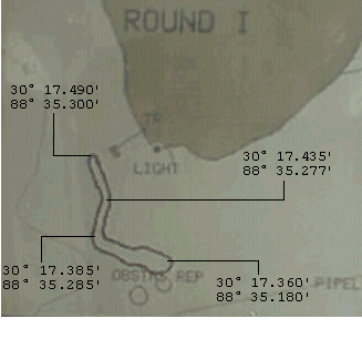
The DGPS Screen image to the left shows the location of the Breakwater in relation to the Lighthouse and Round Island. The Breakwater was simply encircled with DGPS tracking on and then the track frozen upon completion. The Breakwater measures about 1250' in total length. The Lighthouse is located about 500' @ 81° from the northwest end and about 850' @ 353° from the southeast end. Differential GPS Latitude and Longitude coordinates are shown.
 Depth Soundings around the
Breakwater
Depth Soundings around the
Breakwater
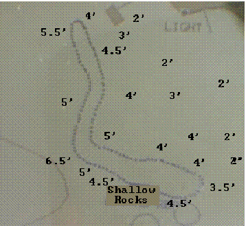
Several depth soundings were taken around the Breakwater as shown on the DGPS image to the left. The readings shown reflect depths at mean low tide. A marked 1X2 board was used to verify electronic soundings. Most of the soundings close to the breakwater read 4'-5' all the way around. The outside of the
dog-leg had a little deeper reading at 6.5' and there were some shallow rocks on the south side of the southeast end. This is actually what gives the appearance of the breakwater being wider at that end since the boat had to avoid this obstruction. It is important to note that the depth quickly shallows to 2' going immediately east of the breakwater and continues for at least 200 yards. This may hamper any additional construction of the breakwater going east.
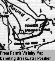
Permit conformance
The geographical placement of the breakwater was detailed by Corp of Engineers permit No. MS96-01802-V prepared by Compton Engineering of Pascagoula. The permit describes construction of the breakwater as follows. "Locate the breakwater approximately 820 feet seaward of the mean high water mark on the south end of the island; construct the base 20 feet wide and crest 2 feet above mean high water at the crest." Cropped images from the permit are shown below and denote the intended position of the breakwater and the phase II backfill.
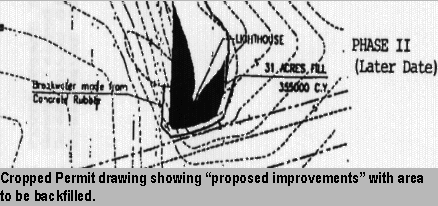
 Comparison of the permit information and the collected construction data shows that while only a small portion
of the breakwater has been completed, its position conforms relatively close with the permit.
Comparison of the permit information and the collected construction data shows that while only a small portion
of the breakwater has been completed, its position conforms relatively close with the permit.
Appendix
The author of this report, Mark Primo Miller, P.E., can be contacted at 228-762-7722 during business hours. Correspondence can be EMailed to Mark@primofish.com or snail mailed to 2210 Denny Ave., Pascagoula, MS 39567.
The Differential GPS unit used is a Northstar 951XD. Satellite information at the time of data collection was as follows: Beginning @ 12:36 PM on 12-20-97, Tracking 9 satellites, Hoop=1.2, Accuracy=10', Differential Beacon was Mobile Point, 300KHz, 100Baud, 30nm. Ending @ 2:12 PM on 12-20-97, Hoop=1.0, Accuracy=8'.
12-20-97 Pascagoula River Tide Information: High @ 1:27 AM = 0.9', Low @ 11:16 AM = 0.1'
Measurements taken between 12:36 PM and 2:12 PM. Little or no tide movement at the time the measurements were taken. There were no noticeable water currents.
Winds were from the East and Southeast at 7-10 knots.
Sunrise @ 6:46 AM Sunset @ 4:57 PM
This Document is available via Internet at http://www.primofish.com/fishcatches/MGFB/reports/round_island_breakwater/LIGHTHOU.HTM